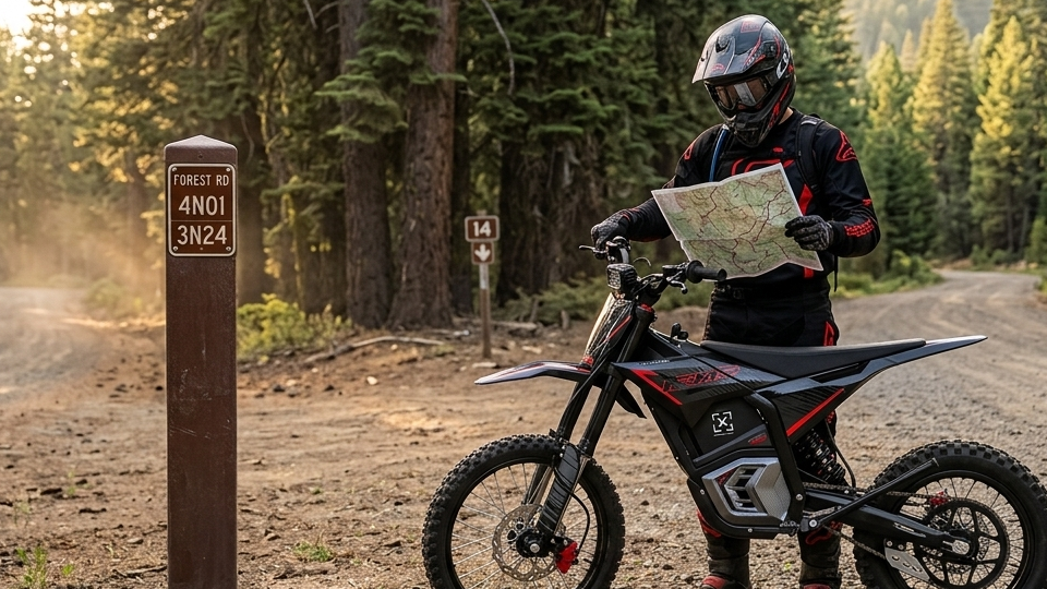
Can You Ride an Electric Dirt Bike on Forest Service Roads?
Sometimes. You may ride an electric dirt bike on a Forest Service road only when the current Motor Vehicle Use Map permits that vehicle class on every route segment, the season is open and all applicable state and local requirements are met.
Verify three things before travel: the machine's legal vehicle class, the designation and season shown on the current MVUM for every segment, and any closure order, registration, equipment, licensing or county rule that also applies. Quiet operation does not create access.
A high-power, throttle-controlled electric off-road motorcycle should not be assumed to qualify as a low-speed pedal e-bike or as a highway-legal motorcycle. Its classification and registration eligibility depend on the machine and jurisdiction, so general statements about e-bikes do not answer Forest Service access.
What follows is the verification method we use before loading a bike: classify the machine, pull the current map, trace every segment, then check the rules the map does not cover. It is a process, not legal advice, and it does not make any motorcycle street legal.
The Short Answer, and the Three Things That Decide It
Access on a Forest Service road comes down to a three-way match. All three checks must be satisfied; an unresolved vehicle class, route designation or local requirement means access is not confirmed.
- Vehicle class. Is your machine a Class 1, 2, or 3 pedal e-bike, an off-highway motorcycle, or a registered highway-legal motorcycle? These are not interchangeable.
- Route designation. What the current MVUM says about the specific numbered road or trail, and about every connector on your loop.
- Everything layered on top. Seasonal dates, closure orders, state registration and equipment law, county rules, local passes.
When the Answer May Be Yes
Proceed only when the current MVUM designates the route for the machine's vehicle class, the season is open and all state and local registration, equipment, helmet and licensing rules are met. Read the legend for that specific forest; do not assume a label has identical meaning everywhere.
When the Answer Is No
Stop if the route is non-motorized, if it lists a class that excludes yours, if it enters Wilderness, or if a seasonal or emergency closure is in force. Under 36 CFR 212.55(e), roads, trails and areas in designated Wilderness or primitive areas generally cannot be designated for motor-vehicle use unless the enabling legislation allows it. Verify boundaries and any specific statutory exception with the managing unit.
When to Treat It as Unconfirmed
Cannot find the road number on the current map. Two sources disagree. The panel you downloaded stops at the edge of your loop. Treat all of that as a no until the ranger district says otherwise. Unconfirmed is not the same as permitted.
MVUM Route Designations, and What Each One Means for You
Forest Service MVUMs use vehicle-class designations, but the exact legend and seasonal table on the current map control. Distinguish roads from trails and all-vehicle designations from highway-legal-only designations before tracing the route.
|
What the map says |
What it means |
An off-road-only electric motorcycle |
|
Roads open to all vehicles |
Open to licensed and unlicensed motor vehicles, subject to state and local law. |
Potentially eligible only if the MVUM vehicle class and all state, local, registration, equipment and rider requirements are satisfied. |
|
Roads open to highway legal vehicles only |
Limited to vehicles licensed under state law for general operation on all public roads. |
Not eligible. No plate, no access, however good the surface looks. |
|
Trails open to vehicles 50 inches or less |
ATV and motorcycle width class. Narrower than a full-size road. |
Potentially eligible when motorcycles are included and the machine meets width and all other applicable requirements. |
|
Trails open to motorcycles only |
Single track. Motorcycles, nothing wider. |
Potentially eligible if the motorcycle class, season and all other requirements are satisfied. |
|
Trails open to all (full size) vehicles |
Rugged, intended for 4x4s. |
Eligible, though rough for a 143 lb bike. |
|
Trails open to e-bikes only |
A newer category added for Class 1, 2 and 3 pedal e-bikes. |
Not eligible. A high-power motorcycle is not an e-bike. |
|
Not shown on the map |
Routes not on the MVUM are not open to public motor vehicle travel. |
Not eligible. This is the rule that catches old logging spurs. |
One more thing that map legend will not tell you. The Forest Service is blunt that legal does not mean prudent, and a low-standard road can be open to everything while still being a bad idea on two wheels.
Why a Dirt Surface Never Decides Access

Surface is not permission. Pavement, gravel, hardpack, mud, ruts, a gate standing open, fresh tire tracks heading in: none of that establishes anything about the legal status of the route.
Tire tracks prove only that someone traveled there. Under 36 CFR 261.13, motor vehicle use must follow the published designations whether or not a sign is present. Penalties depend on the applicable regulation, order and enforcement action; use the current MVUM instead of estimating risk from tracks.
And it compounds. First rider goes cross-country, second follows the line, and inside a season there is a user-created track that looks like a real trail on satellite imagery. Erosion, compacted soil, invasive seed spread into the drainage. That is how forests lose motorized access, one convenient shortcut at a time.
Classify the Machine Before You Open the Map
Do this first. The map is organised by vehicle class, so if you do not know your class, the map cannot answer your question.
A Standard Class 1, 2 or 3 E-Bike
The three-class system separates pedal-assist bikes by assisted speed, with Class 2 adding a throttle. The Forest Service treats all three as motor vehicles and, per its electric bicycle policy, Class 1, 2 and 3 e-bikes are allowed on motorized trails and roads on national forests and grasslands. More than 60,000 miles of trail fall in that bucket.
Opening a non-motorized trail to e-bikes requires a full designation process under the Travel Management Rule, complete with environmental analysis and public comment.
A High-Power Electric Off-Road Motorcycle
Motorcycle controls. No functional pedals. Output far beyond any e-bike definition. Machines like this are generally handled as electric motorcycles or off-highway vehicles rather than bicycles, and there is no single wattage or speed number that settles it in every U.S. jurisdiction.
State definition, federal land manager, and county code can each land somewhere different on the same bike.
This is why ordinary e-bike guidance does not transfer to a high-power, throttle-controlled off-road motorcycle. Evaluate the machine under the jurisdiction's complete statutory definition.
Marketing Names Carry No Legal Weight
E-bike. E-moto. Electric motocross bike. Off-road e-bike. Those are product categories written by marketing teams, not vehicle classifications written by a legislature. A manufacturer name settles nothing about registration eligibility, highway legality, or Forest Service road access.
Record the Specifications Officials May Ask For

Before you call anyone, write this down. Model and manufacturer classification, motor rating, maximum powered speed, throttle arrangement, whether functional pedals exist, VIN or serial details, and current registration status. Staff can evaluate a specific machine from that. They cannot evaluate "an electric dirt bike."
The Seven-Step MVUM Verification Workflow
The Motor Vehicle Use Map is the official designation document, required of every forest under the 2005 Travel Management Rule. It is black and white, carries no topography, and specifies the classes of vehicle and the times of year for which use is designated. Third-party trail apps are useful for positioning. They are not the legal record. Work through these seven steps in order.
Step 1: Identify the Forest and the Ranger District
Confirm the exact administrative unit. Forests split into ranger districts, and both the maps and the local orders can differ across a district line. A nearby mountain town, a state region, or a pin dropped in a trail app is not an administrative unit.
Step 2: Download the Current MVUM
Go to the official forest or district site. Maps are required to be posted online and at district and unit headquarters. Check the publication year, the coverage area, the title, and the legend. Big forests split their MVUM across several sheets or front-and-back panels, so download every panel your loop touches.
Step 3: Locate the Exact Road Number
Match your intended path to its National Forest System road or trail number. Local nicknames, old logging labels, and a GPX track someone posted in 2019 have no standing. The number on the current map is the thing that counts.
Step 4: Read the Vehicle-Class Symbol
Cross-reference the line style against the legend, using the designation table above. The critical read is whether you are looking at a road or a trail, and whether the entry says all vehicles or highway legal only. Get that backwards and everything downstream is wrong.
Step 5: Check the Season and the Date Table
A motorcycle designation does not mean year-round. Read the seasonal tables and the margin notes. Routes close on set calendar dates to limit wildlife disturbance, to protect users from impassable conditions, and to reduce damage to soil, water, and vegetation. A route open on 15 September can be closed on 16 September.
Step 6: Check the Whole Route, Not Just the First Road
Trace the full loop segment by segment. Every connector, every spur, the return leg, each county transition. A road can run legal for eight miles and then turn into a highway-legal-only section for half a mile. That half mile ends the ride for an off-road-only bike.
Step 7: Save Usable Offline Evidence
Cell service disappears in the backcountry. Save the high-resolution PDF or a geo-referenced copy to your phone, and print a panel if you are riding somewhere unfamiliar. Apps help you know where you are. The official MVUM is what settles a conversation with a law enforcement officer.
|
In our experience The legal gap often appears on a connector: the staging road, return leg or a short county link between open forest roads. Trace the entire loop, including the least interesting segment. |
What the MVUM Does Not Settle by Itself
The map handles designation. It does not handle the vehicle, the rider, or today's conditions. Four more layers sit on top, and they can each shut down a legally designated route.
|
Layer |
Who sets it |
Where to check |
|
Route designation |
Forest or ranger district |
Current MVUM, all panels |
|
Closure orders |
Forest Supervisor or Regional Forester |
Alerts and notices page for the district, checked the morning you leave |
|
Vehicle and rider rules |
State law |
State OHV registration, decal, helmet, age, lighting and sound requirements |
|
Public-road segments |
County or state DOT |
County code for any non-forest road on the route |
|
Passes and permits |
Forest or recreation area |
District passes and permits page for the trail system or staging area |
Temporary and Emergency Closure Orders

These override the map, and they can arrive without advance public notice. Under the Travel Management Rule, if motor vehicle use is directly causing considerable adverse effects on public safety, soil, vegetation, wildlife, habitat or cultural resources, the responsible official has to close the route immediately and publish notice afterwards. Fire operations, storm washouts, active logging, wildlife protection. Check the district alerts page before you load, not the night before.
State Registration, Decals and Equipment
The MVUM handles federal route designation; state and local law can separately govern the machine and rider. Registration, helmet, age, lighting, sound and licensing rules change by jurisdiction and vehicle class. Check the current state agency and the responsible forest or ranger district before travel.
Spark-arrester rules are commonly written for combustion-engine exhaust systems, but riders should still confirm how the current forest order and state equipment code are applied at the destination. Electric propulsion does not waive registration, helmet, route, closure or other equipment requirements.
County Roads and Highway-Legal Segments
Forest roads cross and connect to county roads constantly. On many of those, running an off-road electric motorcycle needs local permits, a valid operator licence, or full street-legal equipment. Worth remembering too that a designation reading open to all motor vehicles does not override vehicle size or weight limits imposed by state law.
Local Passes and OHV Permits
Heavily managed trail systems and recreation areas often charge for access separately: day-use tags, season passes, displayed vehicle stickers. Some run under the Federal Lands Recreation Enhancement Act, with fees retained locally for maintenance. A state registration decal does not cover a forest trail-system pass. Check the district passes and permits page.
Signs, Gates and Ranger Instructions
Obey what is in front of you. If a physical closure sign contradicts your offline map, the sign wins and you stop. Same for a gate, a barrier, or an instruction from an officer on the ground. Then call the district to find out which source is stale.
Reading Route Markers on the Ground

Road markers can help with orientation, but post color, number orientation and sign style are not a universal permission system. Match any marker to the current local MVUM legend and closure notices.
- An improved or graded surface does not establish vehicle eligibility. Confirm whether the map designates the segment for all vehicles or highway-legal vehicles only.
- A brown post, vertical number or unimproved roadbed may identify a route locally, but it does not by itself authorize a non-street-legal machine. Use the current legend and route table.
- OHV trail decals may show vehicle type, difficulty or system number. Interpret them using the local legend and current designation.
- A closure marker, gate, barrier or order overrides an older map or app. Stop and confirm the route status with the managing office.
Mixed-use roads carry everything at once, from a loaded pickup to a dirt bike, so keep the speed down and stay right. Also worth knowing: many forest roads dead-end into private land with limited easements, and plenty of boundaries are not posted. Knowing where you can legally ride is your job, not the landowner's.
Plan a Mixed Route Without Creating an Illegal Gap
Most real rides cross more than one jurisdiction. Verify each Forest Service road, public highway, county road, motorized trail, and staging connection separately.

Forest Access Is Not Street Legality
Permission to ride a National Forest System road does not make a bike street legal. It does not prove the machine can be registered, insured, or ridden on a public highway either. Those are separate tests, run by a different agency, and every Valtinsu model ships off-road only. If a plate is what you actually need, our street legal dirt bike setup guide covers the DOT parts list and the state rules that decide it.
Inspect the Connections Between Motorized Segments
Look for the short links. A quarter mile of non-motorized path, a highway crossing, a county-road section, a trailhead access road, a seasonal barrier. Any one of those can break an otherwise legal loop for an off-road-only motorcycle. Trace it on the current map, not from memory of last season.
Verify the Staging and Transport Plan
Confirm where you may park, unload, and start riding. Check trailer access, parking restrictions, day-use requirements, and whether the staging area actually connects to an eligible route. Do not assume you can ride from a campground, a rental, or a dispersed site to the trail.
If the connecting road needs a highway-legal machine, trailer the bike to an approved staging point instead. Riding it out of a driveway is a separate question with its own answer, covered in our neighborhood riding rules.
One useful exception exists. The Travel Management Rule lets a responsible official designate limited motor vehicle use within a specified distance of certain roads or trails, solely for dispersed camping or for retrieving a downed big game animal. Where that applies, the distance is printed on the map. It is not a general licence to leave the road.
Confirm the Uncertainty With the Ranger District
When official sources leave a gap, call the district that manages the exact route. Give staff the route number, vehicle specifications and registration status rather than asking only whether "electric dirt bikes" are allowed.
Prepare a Route-Specific Question
List the road and trail numbers, your entry point, direction of travel, intended date, and every connector. Flag any highway crossing, county-road section, campground access road, or segment that two sources show differently.
Describe the Motorcycle Accurately
Give the model, manufacturer classification, motor rating, powered speed, throttle and pedal configuration, VIN status, and registration details. The model user manuals and spec sheets carry most of it in one place. Do not call a high-power electric motorcycle an "e-bike" hoping for a simpler answer. You will get an answer about a different vehicle, and it will not protect you.
Record the Source and the Date
Note who you spoke to, the date, what they said, the webpage or closure order referenced, and the MVUM edition. Save it. A phone call can clarify published information, but an informal answer does not override a current law, an active closure, a posted restriction or an official order. Recheck conditions shortly before you leave.
Ten Mistakes That Get Riders Cited
Run this list before you load. If any line describes your plan, stop and go back to the map.
- Assuming every fire road is open to motorcycles.
- An open gate or a set of tire tracks treated as proof of access.
- Following an undesignated route because other people clearly have.
- Working from an outdated MVUM, or an undated screenshot of one.
- Checking only the first segment of a mixed route.
- Reading "roads open to all vehicles" as a waiver of state registration and equipment rules.
- Pedal e-bike access borrowed as permission for an electric motocross bike.
- A trail app used as the final authority.
- Riding around a closed gate, barrier, or posted sign.
- Quiet operation assumed to make prohibited use acceptable. It does not.
How We Built This Verification Method
This is a workflow, not an opinion. Three things shaped it.
Primary Sources Only
The permission framework uses Forest Service guidance and the Code of Federal Regulations. Current route status, temporary orders and state requirements still need a fresh check before each trip.
Route-Level, Not Bike-Level
A general "are electric dirt bikes allowed" answer is incomplete. Access attaches to a designated route, vehicle class, season and layered rules, so the method starts there and works back to the machine.
Written for the Awkward Middle
Pedal e-bikes have clear guidance. Registered motorcycles have clear guidance. The high-power off-road electric machine has neither, so this guide is built around it specifically.
Before You Load the Bike
Classify the machine. Download the current MVUM for the responsible ranger district. Match every route segment to the exact vehicle class and season. Check the alerts page, the state rules and the county code. Then, if anything is still unresolved, call the district before you transport the bike or buy one for that destination.
Verify the map before loading the bike. Rules vary by forest, district, state, county, route, season and order, and this guide is a verification method rather than legal advice or proof that any model is street legal or registrable.
Verify the route first. Buy the bike second.
After confirming route legality, compare the Valtinsu electric dirt bike lineup and review the EM-5 Pro product page for current model information; neither link proves road or trail eligibility.
FAQs
Can You Ride an Electric Dirt Bike on Forest Service Roads?
Sometimes. The exact route must be open to your vehicle class, and the bike and rider must satisfy applicable state and local requirements.
- Find the current Motor Vehicle Use Map for the correct forest and district.
- Match the route number, vehicle-class designation and seasonal dates.
- Check temporary forest orders, fire restrictions and state OHV requirements.
- Carry the map offline or on paper and follow on-the-ground closures.
Does a Dirt Road Automatically Mean Motor Vehicles Are Allowed?
No. Surface type tells you nothing about legal access. A dirt road may be private, seasonally closed, limited to highway-legal vehicles or designated non-motorized. On National Forest land, use the current MVUM and orders—not the appearance of the road—as the authority.
Is It Legal to Ride an Electric Dirt Bike on a Public Road?
Only if the bike, rider and road meet that jurisdiction’s on-road rules. Forest motorized access and highway legality are separate tests. A route open to OHVs does not automatically make an off-road-only bike legal on public streets, where registration, equipment, licensing and insurance may apply.
Do I Need an OHV Permit for Forest Service Roads?
It depends on the state, vehicle and trail system. Verify both layers before travel:
- State OHV registration, decal or nonresident permit for the machine.
- A separate local trail-system pass, day-use fee or recreation permit.
Having one does not automatically satisfy the other.
Do I Need a Spark Arrester on an Electric Dirt Bike?
A spark arrester is designed for combustion exhaust, but the current forest order and state equipment rule control admission and operation. Confirm the requirement with the managing unit; fire closures, registration, helmet and route restrictions still apply.
Can I Ride From My Campsite to the Trail?
Only if every connecting segment is open to your vehicle class. A short campground or county-road connection can be the illegal part of an otherwise legal ride.
- Identify the campsite, connector road and trailhead on the current official map.
- Check whether the connector requires a highway-legal vehicle.
- Verify any designated dispersed-camping travel allowance printed on the map.
- Trailer to the staging area when any segment is unclear.
Sources
- USDA Forest Service, Motor Vehicle Use Map (MVUM) Information and Frequently Asked Questions (2026)
- USDA Forest Service, Electric Bicycle Use (2026)
- Electronic Code of Federal Regulations, 36 CFR 261.13, Motor Vehicle Use (2026)
- Electronic Code of Federal Regulations, 36 CFR Part 212 Subpart B, Designation of Roads, Trails, and Areas for Motor Vehicle Use (2026)
- Electronic Code of Federal Regulations, 36 CFR 212.55, Criteria for Designation of Roads, Trails, and Areas (2026)
- USDA Forest Service, Francis Marion and Sumter National Forests, MVUM Responsibilities and Prohibitions (2025)
- USDA Forest Service, Mendocino National Forest, Off-Highway Vehicles (OHV) (2025)


Looking for something else?
Electric Dirt Bike Replacement Parts Availability: What Buyers Should Verify Before Ordering
LEARN MORE
How to Check an Electric Dirt Bike for Safety Recalls by Model and Serial Number
LEARN MORE
How to Choose an Electric Dirt Bike Repair Shop: Questions to Ask Before Service
LEARN MORE
How to Lift a Fallen Electric Dirt Bike Without Hurting Yourself or the Bike
LEARN MORELooking for something else?
Electric Dirt Bike Fall Riding on Wet Leaves: Grip, Hidden Obstacles and Braking
LEARN MORE
Electric Dirt Bike Trailside Power Loss: Recovery Plan When the Battery Is Dead
LEARN MORE